
Friday I got out of work a bit early and hit the road right away. I was all packed and didn’t even stop by the house on my way out of town. I listened to an audio book and drove about 3.5hrs south to Fayetteville and stopped for a burger and a couple of local beers at Foghorn’s. It was all really good and fast and in no time I was full and back on the road. 30 min later I pulled into the visitor center parking lot at Lake Fort Smith State park and the first trail head on the Ozark Highland Trail.
I changed clothes and got all my gear in the truck and on my pack situated. It was a humid 68F and I was hot before I even put my pack on so I went ahead and packed the under-armor long sleeve shirt and the hunter orange over shirt I was planning on wearing. I hit the trail in a tank top, canvas pants and headlamp, looking pretty creepy.

I could not find the real start of the trail but I knew the general direction so to add to the creepy I bee-lined to the trail cutting right by some occupied campsites. It was a little rough going getting to the trail but eventually I found some white blazed trees and then a sign.

From that point on the trail was great. Even in the dark with lots of new leaves on the ground it was easy to find and follow. I saw some cool old chinmey’s and foundations and the rocky bluffs looked like they would be really interesting in the daylight.

I startled quite a few deer. I saw lots of little bright green reflective spots in the leaves everywhere and eventually got right up on one and found it was a spider. I’d also hear leaves slowly crunching along, it sounded like the wind but there was no wind and when I would get close to them armadillos would take off in a crazy rush.
I could not see it but I knew from the map I was following north along the edge of a lake and I would eventually need to go around the top of it and then head east. I’d read some horror stories of water crossing at the top taking people an hour or more out of their way. I was a little nervous of how this would go for me and if it would stop my progress for the night.
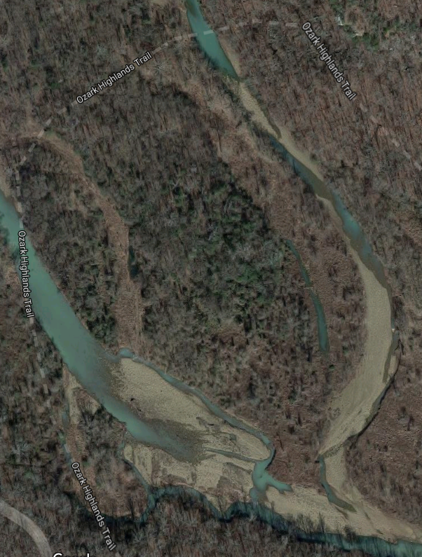
It turned out to be no big deal, it was dry and I didn’t even end up stepping over a puddle, just dry smooth river rock. I went about 2 more miles following the other side of the lake. I checked my map and decided after about 2 hours of hiking it would probably be a good idea to setup camp. The trail was about to leave the lake and follow a creek occasionally crossing it. I was a hot sweaty mess and had already drank a lot of my water and I knew I would need to find more in the morning and didn’t want to risk getting wet before bed. So I set up camp on a rocky hill above the trail.

(picture taken the next morning, see the lake in the distance)
I hung my sweaty shirt, socks, pants and boots to dry and discovered I already had worn a blister.

I climbed into my hammock and read my book on my phone a bit until I was cooled down and sleepy. I was a little worried about bugs and kept my tarp pretty tight over my hammock but I was not bothered by any.

I slept pretty good and at about 6:45 in the morning I awoke to the sounds of gunfire. It sounded like several hunters were out in various directions. I climbed out and put on my bright orange shirt while I packed up camp, tossed some duck tape on my blister and headed back to the trail.

I barely made it to the creek before I was sweating a bunch and decided to lose the shirt.

The creek crossing was obviously not a problem. I was a little worried I’d have to really search for water.

About an hour later I found some.

I filled up my bottle and drank it all twice then filled it up again for the road.

At this point I had a bit of a headache, was really hot and sluggish and not very motivated. I started to consider shortening my trip and spending some time hanging in the hammock reading and napping. When I came to the next nice water crossing, about 2 hours from when I started I stopped to cook breakfast.

I filled my little cup with as much oatmeal as I could fit and then I filled my big cooking pot with steaming hot coffee.

I’d passed 2 backpackers a little ways back and they caught up to me at the creek and I watched them head on down the trail. I looked over the map and started thinking about going to Richardson Mountain at mile 13 and not continuing on to White Rock Mountain at mile 17.
The oatmeal and coffee was great and I took a couple ibuprofen and filled and drank my water bottle a couple times also. My breakfast spot was beautiful.

By the time I was packing up my stuff to hike on I was feeling great. It had cooled off enough by this point to wear my shirt as I got going again with a full load of water.

I decided to set a fast pace but stop anytime I saw something with an interesting color or texture or otherwise picture worthy.

I started to notice how really exciting this hike was and awesome the area was. There were lots of easy creek crossings and the trail followed along the top or bottom of bluffs much of the time. I passed the other guys shortly later and in no time I was nearing the flat top of Richardson Mountain and looking down.

By the time I reached mile the 13th mile marker, I had a whole new plan. The marker was in a very identifiable spot but I still marked it with the GPS on my phone and took a picture.

I climbed up on top of that big grey rock and changed into sneakers and moved the essentials to a camel-pack. I hung my 50 pound pack in a tree with the rain cover on and hit the trail feeling lighter and really good. I also ate a tortilla roll up.

I was low on water again but when I got to flat spots or slightly down hill areas I jogged. I eventually crossed a stream and did the whole drink a whole bottle and fill a whole bottle trick before moving on.

It was my first trip with this new life straw bottle and I loved it.

It was easy to fill anywhere and easy to drink out of. I hiked and jogged on and on. I could see the white rock mountain peak but had to make my way all around it before getting to the trail going up it.

I felt like I was going really fast but it was taking a lot longer to get to the top then I planned. I was on a pretty steady incline but the trail seemed to never turn up to the peak.

Then finally it did.

It was a bit disorienting when I hit the top as I came up near an old stone cabin but no sign of the main overlook and shelter I had seen in the pictures. I saw a few cars and was on a road and followed it past a few more stone cabins. It was around this point I saw this sign and discovered why it had taken so much longer.

I was 19 miles in, not 17. Then I found the shelter and the overlooks.


I also found some crazy wind and the light mist of rain was starting to fall a little heavier.

So I took a few pictures, admired the view and got out of there. My phone was warning more rain coming.
I looked at the map and found a shortcut on the road I had thought I saw earlier and deiced to cut out a couple miles on the way back. Walking the road was a nice change of pace with new views.


I passed a campground and filled up on clean water and got another tortilla roll up. I had stuffed wheat tortillas with salami, cheese and lots of humus so they were pretty dense. I made it back to the trail and jogged the flat areas and speed walked the rest. I saw the guy and his son again and they teased me a bit about giving up before I told them I had already made it to the top and was on my way back. I told him with out my pack I was able to jog a bit and really make good time.
I got back to my pack and it was dry and had not new squirrels in it or anything. I just strapped the camel-pack to the top and kept moving. I was soaked through and it had really cooled off with the cold front but I was burning so much energy I was still sweating. I hiked from mile 13 almost to mile 8 as I slowly got more worn out, tired and cold. I made it to the bottom of the hill with a really nice campsite that was out of the worst of the wind with a really nice fire pit and “furniture” people had built up with rocks and stuff. It was 3:45 but I was ready for dinner so I got some water from the creek boiling and put on some music. I added Mexican rice and dehydrated pinto beans.

I was pretty sure this awesome camp was going to be the end of my day if I didn’t just fall asleep waiting for dinner to cook.

I drank a bunch of water as I knew I’d have sources pretty easy the rest of the way. I started to get cold so I boiled water just to help warm me up. After eating all the rice and beans and a protein bar I felt good. I took off my cold wet sneakers and socks and put on dry socks and fairly dry boots and fresh duck tape. I decided to hike on a bit to kill some time, warm up and make Sunday easier. As dusk approached I heard a few shots but they were a long way off this time. I was feeling full of energy again and hiked on through dusk. I had some dry clothes in my bag, another tortilla roll up, some tea, oatmeal and granola bars.
I went back and forth in my head about how far to go. Eventually I started thinking about milk shakes and cheese burgers and how much better they sounded then tea and tortilla roll ups. I figured out that if I kept it up I could reach the truck by 7 or 7:30 and have a total change of clothes a heater and access to milkshakes and cheeseburgers. With a nice hot coffee and audio book that 4hr drive home did not sound bad at all.
So I hiked my butt out of there. It was not easy and even though I didn’t take many pictures I stopped to rest more then I had all day. I was disappointed I didn’t get to see the start of the trail in the daylight but the sunset on the lake was really cool.

I followed the signs to the start of the trail instead of cutting through campsites and I never thought it was going to end but I finally found the start.

I got the truck warming up and put on thick dry socks, shoes, pants, underwear, shirt and sweatshirt. All the sweat-soaked stuff went right into the bed of the truck.
My legs and back were dead. I went to the closest McDonald’s and gas station and loaded up on calories and caffeine. I ended up listening to a podcast about the trail for a good portion of the drive back and the drive was not bad at all. Once home I showered and slept pretty hard.

Google Trail map: https://www.google.com/maps/dir/35.6956653,-94.115927/35.6852979,-93.9618335/@35.6977065,-94.0592622,13.5z/data=!4m2!4m1!3e2
Topo map: https://michaelr42.files.wordpress.com/2017/09/map-oht-v1.pdf
Description: http://www.ouachitamaps.com/OHT-01LakeFS-Cherry.html
Destination: https://www.whiterockmountain.com/
Destination image: https://i.ytimg.com/vi/rAVB1l82r6Q/maxresdefault.jpg